April 7, 2016
A Radical Plan to Save the Mississippi Delta
Studio MISI-ZIIBI has developed a 100-year strategy for the lower Mississippi.
The Atchafalaya, part of the larger Mississippi River Delta, meets the Gulf of Mexico.
Courtesy Derek Hoeferlin
This article originally appeared on the blog of the Washington University in St. Louis, The Source.
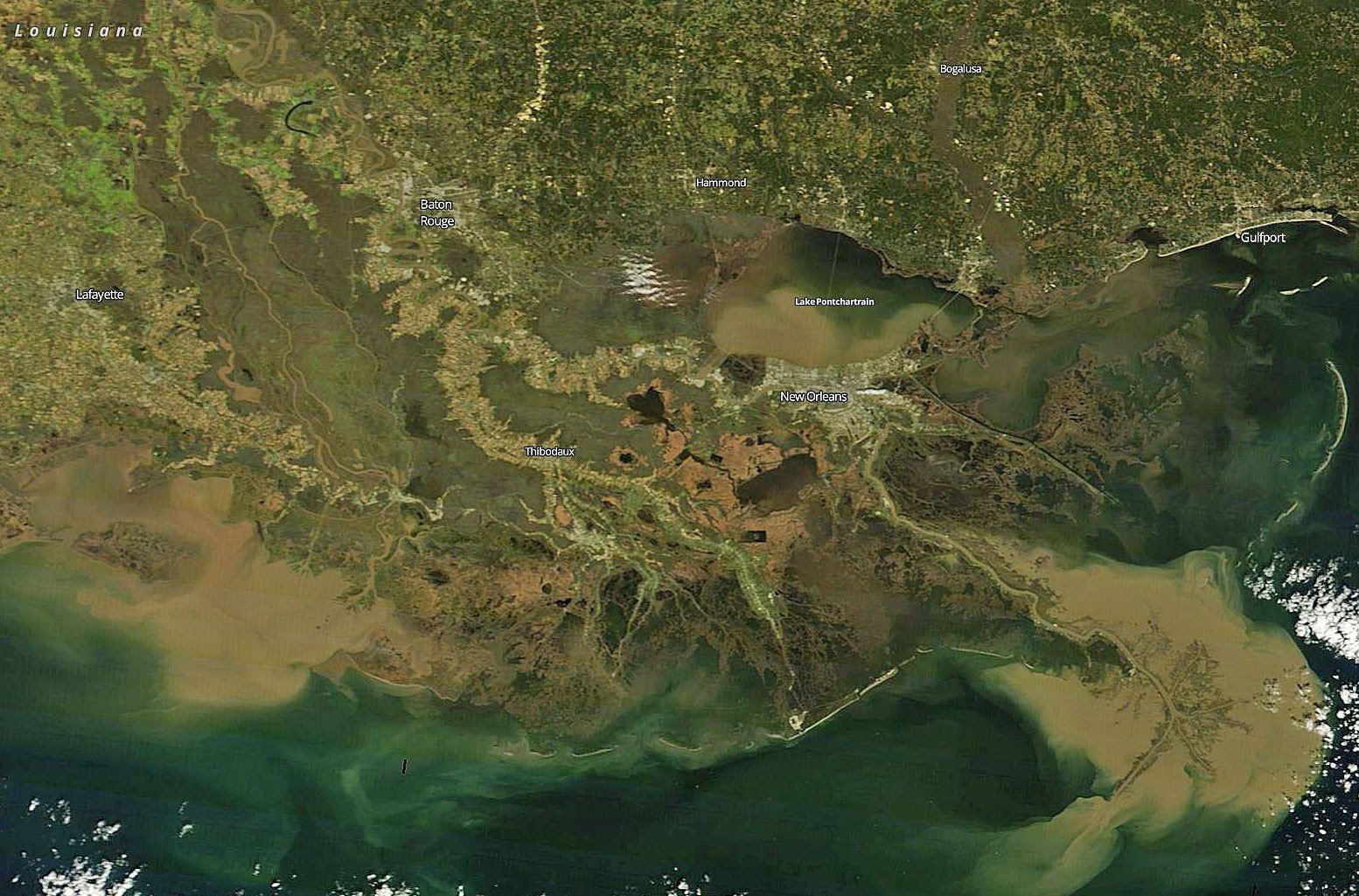
On Jan. 9, 2016, as record floodwaters roared down the mid-Mississippi River valley, hundreds gathered on the shores of Lake Pontchartrain to witness theopening of the Bonnet Carre Spillway. Completed in 1931, the spillway was engineered as a safety valve for the City of New Orleans, diverting floodwater through Pontchartrain and out to the Gulf of Mexico.
In satellite images, that diversion can be seen as a large brown bloom overtaking much of the lake. But for those who study the Mississippi River Delta, the bloom was a lost opportunity. Millions of tons of rich river sediment—the delta’s basic building block, which might have been used to staunch coastal erosion—instead washed out to sea.
“Wetlands are built primarily in times of flood,” says John Hoal, professor and chair of urban design in the Sam Fox School of Design & Visual Arts at Washington University in St. Louis. But today, for a long list of reasons, “the delta is shrinking. We’re losing communities, we’re losing ecosystems.”
If nothing is done, Hoal says that “by 2050, New Orleans could be a coastal city.”

With the opening of the Bonnet Carre Spillway, millions of tons of rich river sediment passed through of Lake Pontchatrain and out to the Gulf of Mexico.
Courtesy NASA Terra MODIS satellite
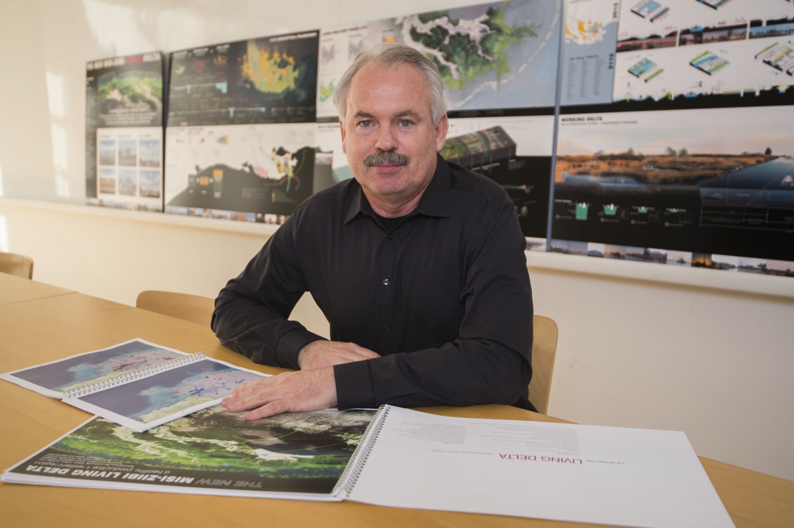
John Hoal at H3 Studio in the Central West End.
Courtesy Joe Angeles/Washington University
‘Changing Course’
Hoal has spent the last decade studying the lower Mississippi. In the wake of Hurricane Katrina, his firm, H3 Studio Inc., helped coordinate the Unified New Orleans Plan. More recently, he has led teams investigating the river and climate change.
“It’s an incredibly complex problem,” Hoal says. “Saving the delta will require a comprehensive, integrated and synergistic approach. You can’t do it in pieces. You have to reorganize the system.”But in 2014, Hoal convened designers, engineers, hydrologists, planners and other professionals—along with a handful of Sam Fox faculty, students and young alumni—into an international group known as Studio MISI-ZIIBI. Last fall, the group was among three winners in Changing Course, a global competition charged with developing a 100-year plan for stabilizing the delta.
That system includes a delicate ecology encompassing both fresh-water and saltwater conditions. It also includes the Louisiana economy, which relies heavily on oil, gas and shipping, as well as the Mississippi itself. Over the last 7,000 years, the river has shifted course six times—a natural process that built the delta as we know it, but which complicates the task of maintaining a navigable channel.
And then there’s climate change. “People down there know where the water was five years ago and where it is today,” Hoal says. “Those with means have already moved.”
Which raises yet another set of issues: “How do we deal with cultures and communities, some very historic, that live outside protected areas?” Hoal asks. “How do we help the most vulnerable populations?”
Delta building
Extending like a giant claw into the Gulf of Mexico, the “bird’s foot” delta boasts some of the nation’s most varied and distinctive habitats.
Today, the bird’s foot is under siege from all directions. Gulf currents, rising tides and tropical storms wear away the coasts. Oil and gas canals allow saltwater to penetrate the wetlands, killing Cypress trees and other freshwater vegetation. Massive levees starve the delta of replenishment.
“The delta wants to grow,” says water management scholar Derek Hoeferlin, assistant professor of architecture and a core Studio MISI-ZIIBI member. “We’ve cut off that process. Now the delta is sick. Instead of growing, it’s eroding.”
Yet even if the river could be returned to a free-flowing state—a practical and economic impossibility—Studio MISI-ZIIBI’s engineers and hydrologists, drawn from top firms such as URS and HKV, calculate that upriver damming and diversions have reduced available sediment by half.
Thus, Studio MISI-ZIIBI proposes a strategy of retrenchment and rebuilding. A new river mouth, or “head of passes,” near West Point à la Hache would shorten the river below New Orleans by almost half, but also would render it faster, steeper and more resistant to storms. Eight sediment diversions (coordinated with four more along the Atchafalaya) would replace the Bonne Carre Spillway and begin re-growing land. River dredge could be used to supplement the process.
The end result, says Hoal, would be a smaller but stronger and more sustainable bird’s foot.
“This is a radical proposal,” he says. “It’s going to require a lot of money, agreement and political will. But there are pragmatic reasons for it.
“Right now, the delta is on life support.”
Working delta
The Old River Control Structure is a system of locks and dams built by the Army Corps of Engineers at the Atchafalaya confluence. Without it, the Mississippi River would have jumped banks long ago, stranding the ports of New Orleans, Baton Rouge and Southern Louisiana.
“The delta today is an engineered landscape,” Hoeferlin says. “It’s an amazing system, but a 20th-century system. It doesn’t account for climate change, population shift and other variables. And if it fails, the results are catastrophic.
“We’re proposing a new paradigm,” Hoeferlin says. “We need transportation, but we need to bundle it with restoration. Ecological urbanism isn’t about letting things go back to nature—it’s about lacing communities and ecologies together. It’s about building resiliency.”
For example, the new head of passes would shorten the route to deep ocean waters, reducing dredging costs. This would allow maintenance of a 45- to 50-foot channel, which in turn could accommodate the next generation of Post-Panamax vessels.Project manager Matthew Bernstine, a 2014 Sam Fox graduate and current senior lecturer, points out that many of Studio MISI-ZIIBI’s delta-building elements both “accommodate existing economies and build on existing geographic strengths.”
Meanwhile, smaller channels and canals would be consolidated into highway-like networks of hydro-infrastructure corridors—reducing saltwater backflow while also maintaining access to inland resources and energy transmission pipelines.
“Utility right-of-ways are well-established on land, both in cities and in mountain regions,” Bernstine says. Applying the concept to maritime conditions “would provide a model for expanding into new sectors (such as wind or tidal power) and transitioning into a new climate economy.”
Implementing such a network is well within our technical capacity, Bernstine adds. The main challenge would be untangling the delta’s Byzantine system of property rights.
“Who owns the wetlands, who owns the water, who owns the oyster beds, who owns the substructure below the soil—these are all complicated questions,” Bernstine says.
“But they are legal and political questions, not physical obstacles.”
Two proposed developmental typologies. In the far reaches of the delta, temporary structures (left) could facilitate ecotourism. In urban settings, water could be integrated into daily activities while restored wetlands would serve as a natural storm buffer, reinforcing the levee system.
Courtesy Andy Lee H3 Studio.
A living delta
In the lower delta, water can seem both friend and foe—a vital resource that enables and endangers a way of life.
But when it comes to river management, the balance too often tilts towards fear. “Water is not the enemy,” Hoal says. “Flooding is not bad for this landscape. The entire ecosystem depends upon floods. The question is one of control.”
On many topics—sediment diversions, the future of the bird’s foot—all three Changing Course winners reached similar conclusions, and competition organizers are now working to integrate their findings into Louisiana’s 2017 Coastal Master Plan.
What distinguished Studio MISI-ZIIBI was its close attention to community planning. Specifically, the group detailed five development typologies, each predicated on a different protection level and investment strategy, but all embracing water as a regional advantage.
At the farthest reaches, low-investment temporary structures, such as cabins or hunting blinds, could foster recreation and ecotourism. Fishing village and other communities outside levee protection could accommodate new construction by elevating above projected sea-levels.“Economy and ecology are intrinsically tied together,” says Andy Lee, a 2015 architecture alumnus who helped illustrate the concepts. “By promoting a healthy relationship with water, we hope to strengthen delta communities and create sound foundations for delta living.”
Under-developed communities already behind levees—such as Houma, Thibodaux, Violet and Meraux—could be revitalized with new public waterfronts. Those bound within the state’s Bayou Lafourche ring levee could be retrofitted for increased density.
“Right now, in the City of New Orleans, we turn our backs to the canals,” Hoeferlin says. “But imagine if we reoriented. Imagine a community with less parking and more boat traffic.”
“We have to learn to live with water.”
A global leader
Uniting all of these proposals is the conviction—at once urgent, ambitious and optimistic—that we can and will rethink the relationship between nature and human development.
“This is an incredibly beautiful landscape,” Hoal says. “It takes your breath away. It’s one of the world’s great tidal systems.
“The problems we see here are the same we see in other delta cities—in Shanghai, in Lagos, in Singapore,” Hoal says. “Cities have been built in deltas for thousands of years. We’ll always want cities where the sea meets the river. But the engineering solutions we’re using no longer work. By its very nature, the delta has to change and evolve.
“We can guide that change,” Hoal says. “We can design a system that is organic and self-regulating. We can reinstate ecosystems and improve things for industry. Most of the technology exists today.
“Louisiana has an opportunity to become a true global leader.”
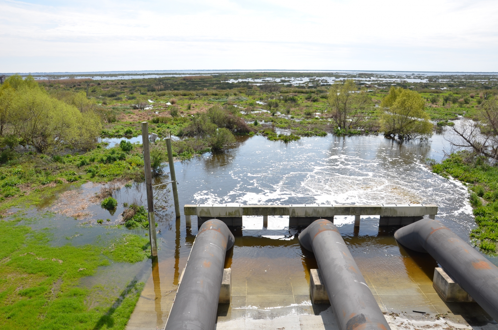
Freshwater pumped away from the protected side changes the saline balance.
Courtesy Derek Hoeferlin
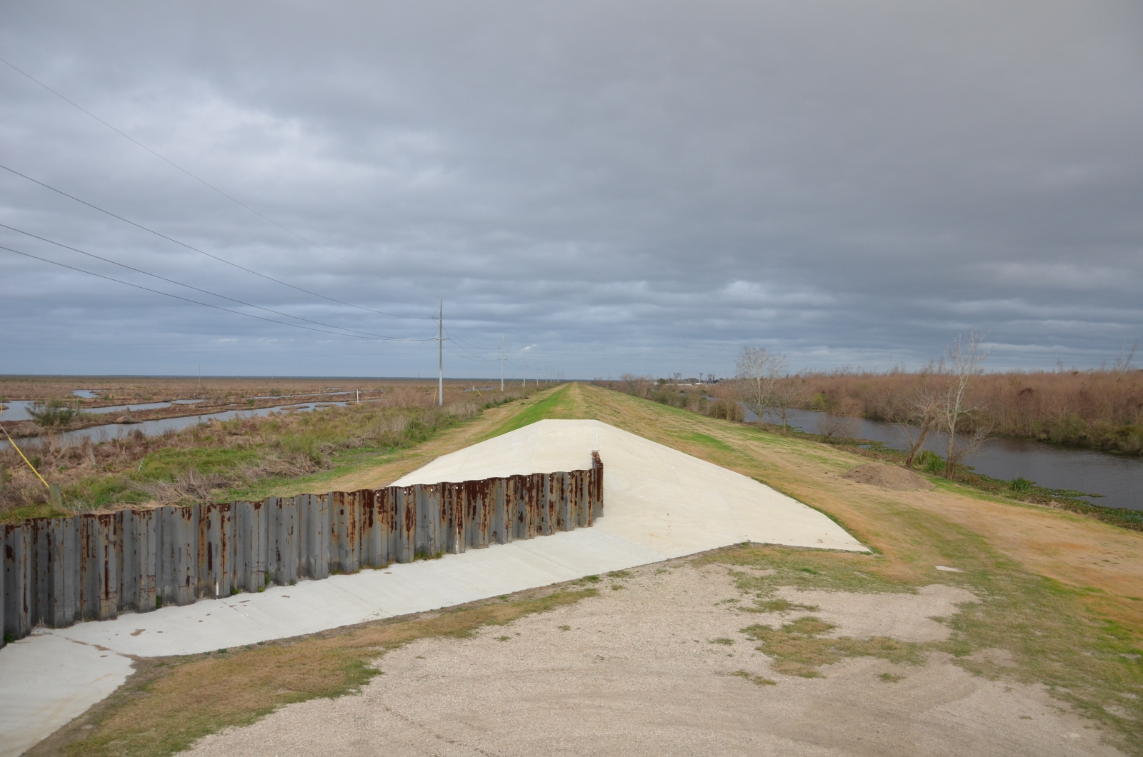
An earthen levee south of New Orleans. Land in the protected zone, at right, sits approximately six feet below the saline marshes at left.
Courtesy Derek Hoeferlin

“We had done research about the region in class the previous semester, so we were already familiar with the context of Changing Course,” says Cristina Clow (B.Arch ‘15), one of four architecture students who worked on Studio MISI-ZIBBI as part of an independent studio. “We were constantly asking how to represent ecological and social aspects that effect the entire Mississippi River, but also function on small, local sites.”
Courtesy Cristina Clow, H3 Studio
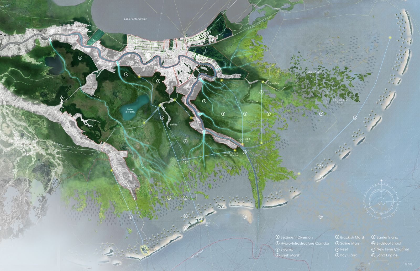
The Studio MISI-ZIBBI proposal would replace the spillway with eight sediment diversions. A new head of passes would be located near West Point à la Hache. New barrier islands would be constructed from river dredge.
Courtesy Courtney Cushard and Junru Zheng, H3 Studio

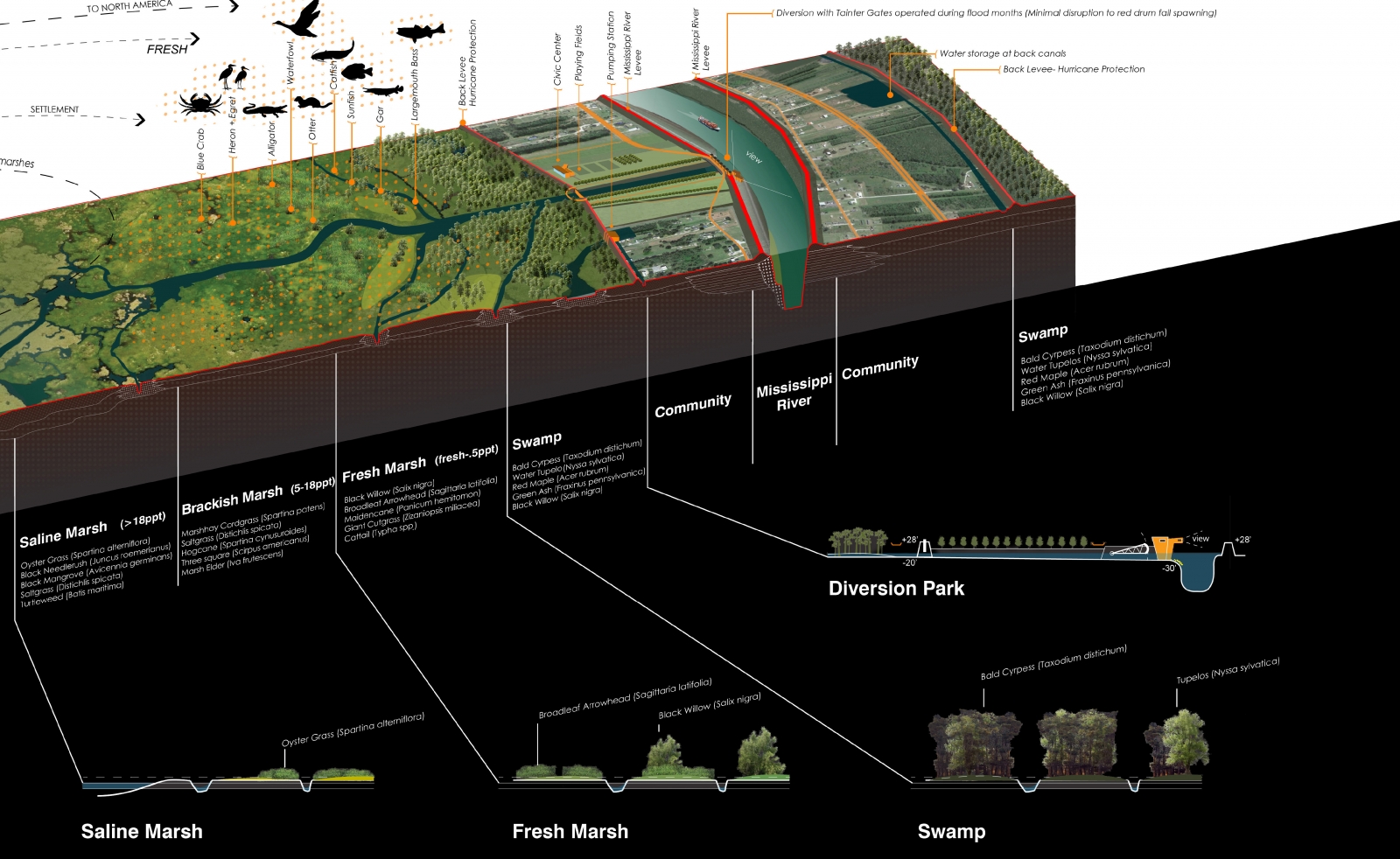
Illustrations of the delta ecology by Taylor Halamka (B.Arch ’15).
Courtesy H3 Studio
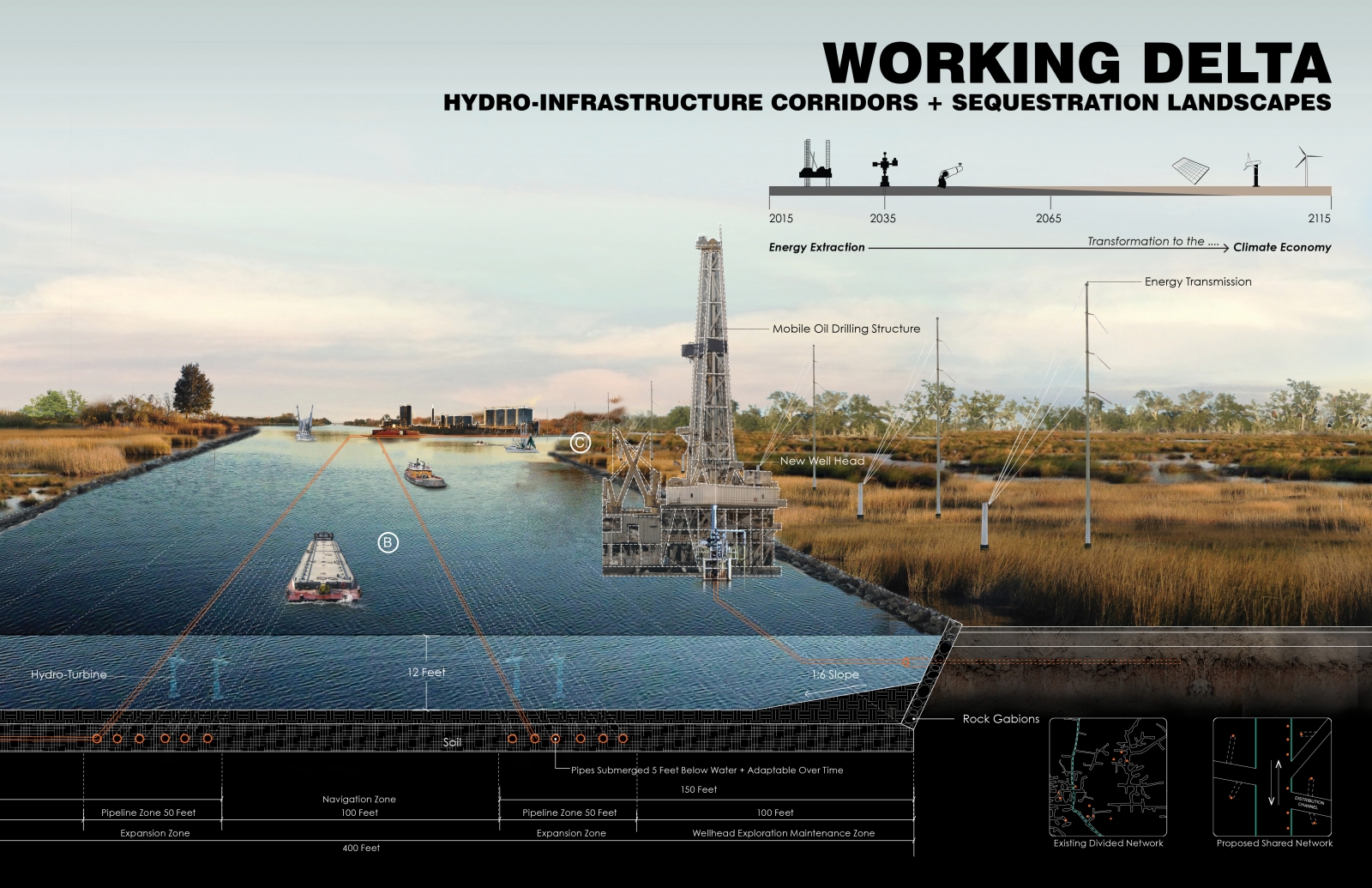
A proposed network of hydro-infrastructure corridors would reducing saltwater backflow while maintaining access to energy transmission pipelines.
Courtesy Courtney Cushard and Junru Zheng, H3 Studio
Recent Viewpoints
Viewpoints
Sustainability News Updates for Q2 2025


